I use AI extensively, but with ownership and responsibility, including in the preparation of this CV.
AR
Mohammad Arifur Rahman (Arif)
PhD-trained Scientific Programmer · GIS & AI Engineer
Visa 485 · full work rights · no restrictions · exp. Jan 2029
01 Summary
A results-oriented programmer who takes ownership beyond formal role boundaries,
delivering end-to-end ML and GIS solutions. 16+ years of software
engineering, a PhD in machine learning for hyperspectral remote sensing, and a
product- and deployment-focused mindset.
Machine Learning
PyTorch, hyperspectral, remote sensing, RAG, LLM tool-use, Azure AI Foundry, LangGraph, Azure AI Search, Power Automate, GraphRAG.
GIS & Remote Sensing ArcGIS Pro, QGIS Desktop/Server, Google Earth Engine.
Development & DevOps Python pipelines, Flutter, React JS, Bash, Azure, AWS, Ubuntu, Playwright.
02 Top Recent Projects by Category
Cloud-native AI
Resource Allocation Assistant
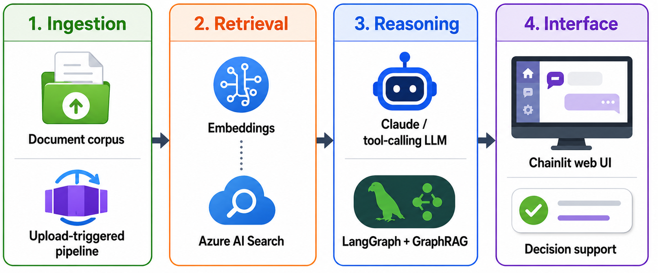
Built an Azure-native assistant that lets reviewers interrogate a large document corpus through multi-turn, tool-using LLM conversations.
Owned the whole stack: upload-triggered extraction and comparative-scoring jobs, vector retrieval, containerised deployment, secrets and CI/CD.
Extended cross-document reasoning with GraphRAG and LangGraph behind a streaming chat UI.
Self-hosted ML
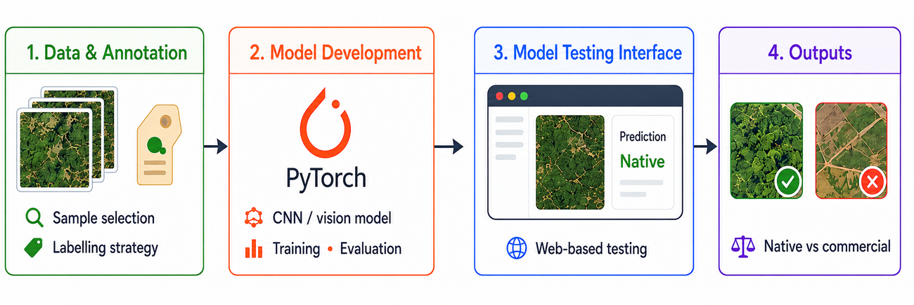
Image Classification — Commercial vs Native Vegetation
Owned the problem end-to-end, from labelling strategy through to a deployed, reviewable model.
Tuned iteratively against domain feedback and served it on Ubuntu for ongoing internal use.
GIS
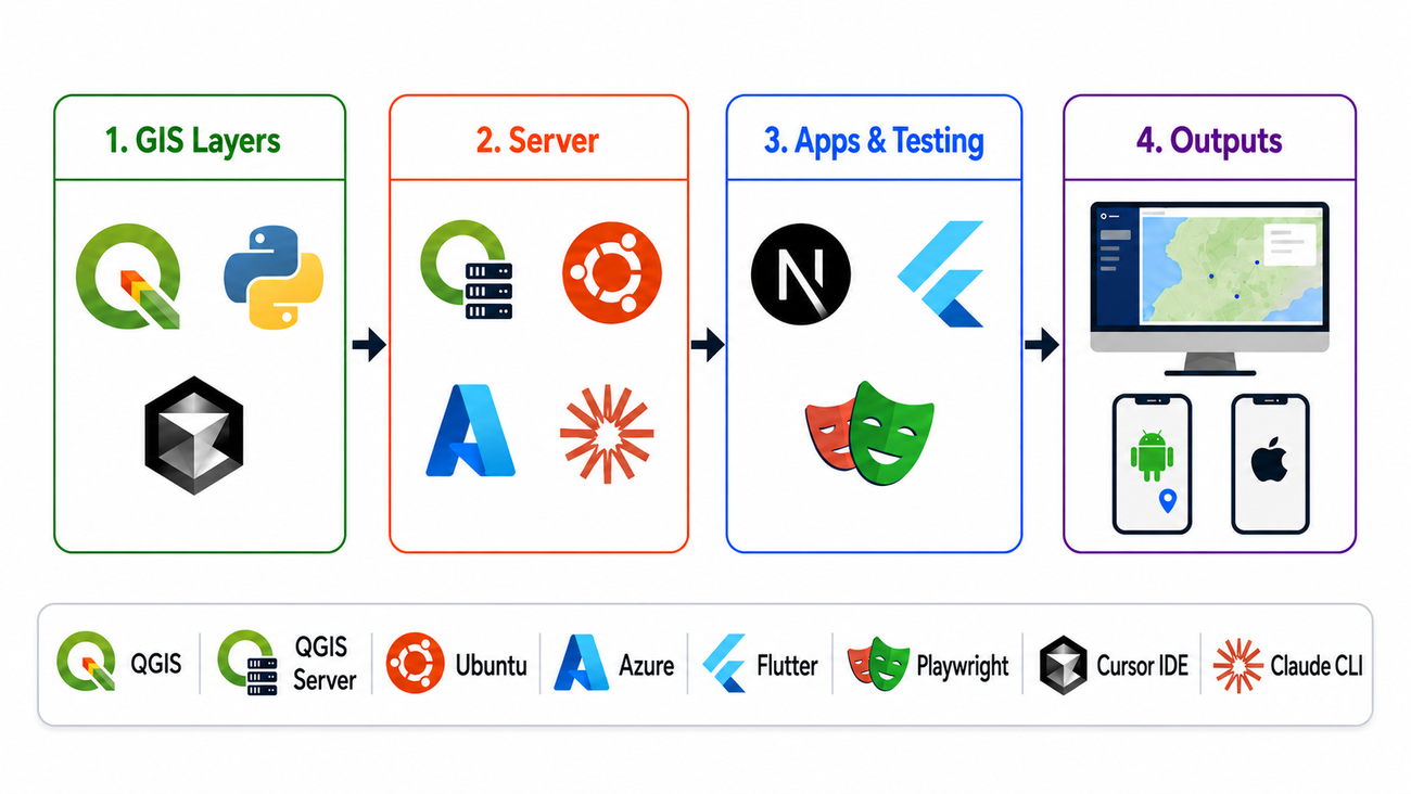
Web GIS Portal & Mobile GIS Apps (Android & iOS)
Delivered interactive GIS layers to office and field users across web, Android and iOS from a single data source.
Worked across the full stack — data, server, apps and test automation — with an AI-accelerated build-and-deploy workflow.
Remote Sensing
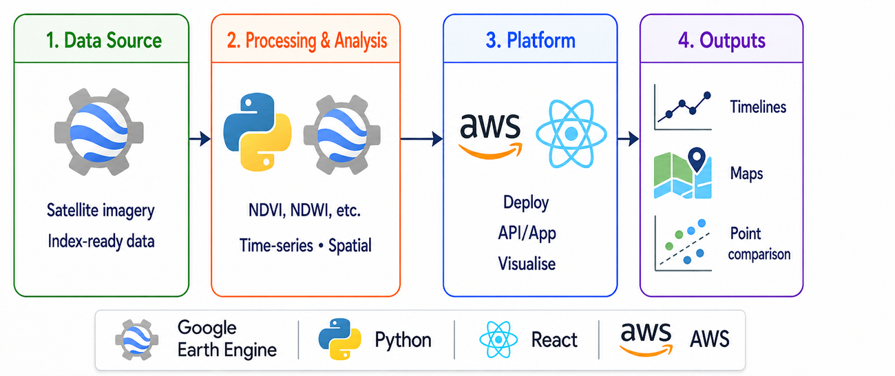
Spectral Index Analysis & Comparison System
Lets analysts track vegetation and water conditions over time and compare any two points spatially.
Turns raw satellite archives into decision-ready spectral signals.
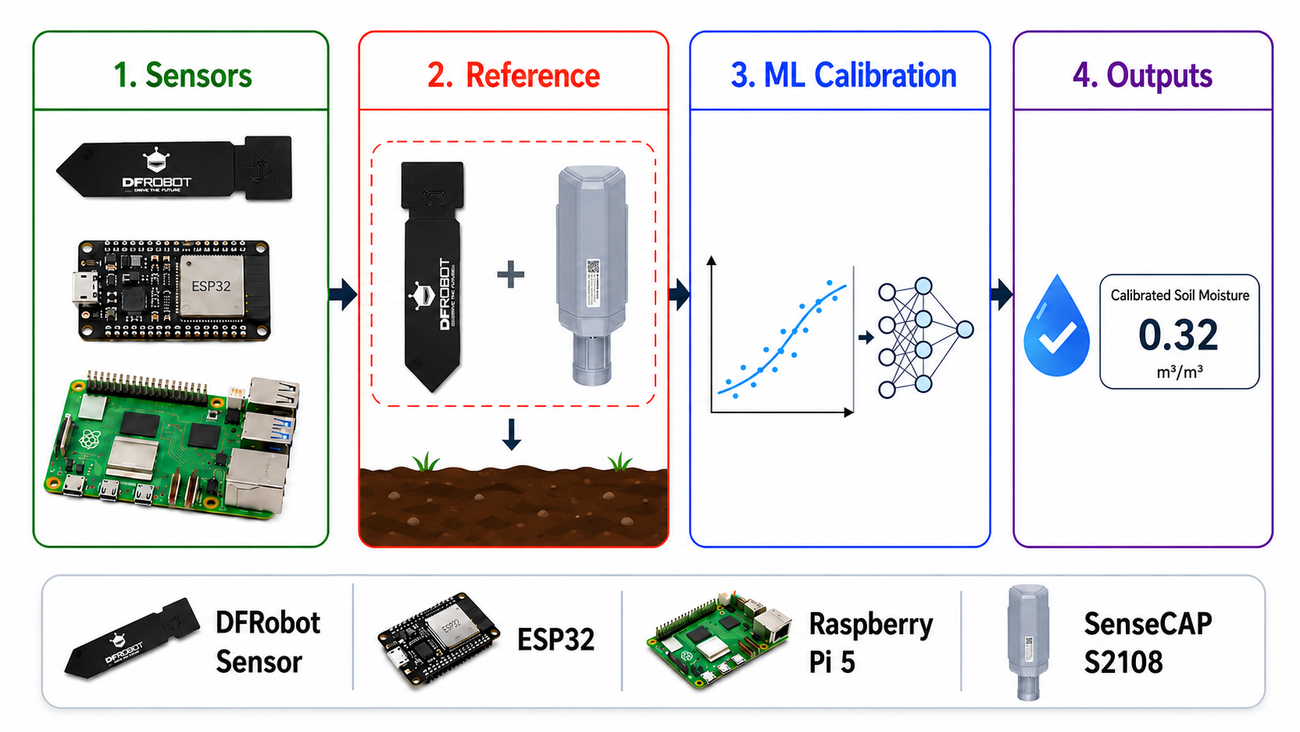
IoT
Low-Cost Soil Moisture Sensor Calibration
Calibrated a low-cost capacitive soil-moisture sensor against a research-grade reference.
Co-located DFRobot/ESP32/Raspberry Pi hardware with a SenseCAP S2108, then trained an ML model to map cheap readings onto reference-grade values.
03 Work Experience
Analyst Programmer
Jun 2025 — present
Wimmera Catchment Management Authority · Horsham, VIC
Machine learning workflows for business and environmental decision support.
GIS and remote sensing data pipelines for spatial analysis, mapping and reporting.
Web and mobile application development for internal tools, data visualisation, and dashboards.
System deployment, troubleshooting and optimisation across cloud and Linux server environments.
Machine Learning Engineer
Aug 2022 — May 2025
WebAlive Pty Ltd · Melbourne
Speech-recognition system to identify international names for automated video clipping.
OpenCV tool to detect and crop faces for ID-card image workflows.
Face-recognition pipeline to cluster and organise photos by identity.
Engineering Manager
Jul 2008 — Apr 2022
Bit Mascot (Pvt) Ltd · Bangladesh
Led delivery as a core developer across 20+ mid-sized and 3 long-term full-stack projects, using Java, Grails, PHP, Bash, Selenium, CentOS and Ubuntu.
Coordinated delivery planning and execution across concurrent client engagements.
04 Education
Doctor of Philosophy (Engineering) Jan 2026
Federation University Australia · Mt Helen, VIC
Soil Carbon estimation from Hyperspectral Imaging using CNN-based algorithms.
BSc, Computer Science Dec 2007
American International University-Bangladesh
GPA: 3.97 out of 4.
Awards: Summa cum laude and Scholarship for Academic Excellence.
05 Selected Publications
IEEE Access · 2025 Sensors 24.23 · 2024 DICTA / IEEE · 2024 Neurocomputing 536 · 2023
06 Field ExperienceParticipated in Monash University’s Active and Passive P- and L-band Experiment, an airborne field campaign led by Professor Jeffrey Walker.